
In this guide Show sections
General guidance, not a professional assessment. Confirm site-specific advice and current requirements before work.
Planning tree work in Bedford or nearby?
Start with the postcode, the work you have in mind and any access considerations.
Prepare your enquiryNo obligation. A site assessment may be needed to confirm the work and price.
Before you start
First establish that the tree is within Bedford Borough. Our council-area guide explains the check for addresses or land outside it. The walkthrough below concerns the resources linked by Bedford Borough Council, not a single mapping system covering every Bedfordshire address.
Read the map and the record
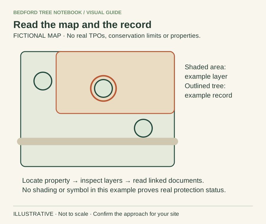
- Find the actual property on the official council map.
- Inspect relevant layers and open the linked order or document.
- Ask the council where the record or boundary is unclear.
Background sources: Bedford Borough Council guidance
Open the map from the council’s own page
Begin at Bedford Borough Council’s protected-trees page. It links to the Planning interactive map, conservation-area resources and planning how-to guides. This is a more dependable starting point than an old bookmark or an unattributed third-party screenshot.
The council currently points readers to How to Guide 2 for map help and How to Guide 8 for protected-tree information. Interfaces can change; follow the current official instructions if a control looks different from an older guide.
Identify the right location before reading layers
Find the address or site and check that you are looking at the correct garden or parcel. Compare visible boundaries and the tree’s position with what you know of the site. If the address point sits away from the actual tree, take care not to search only around that marker.
Use ordinary location notes such as front or rear garden and a labelled plan. Do not guess the identity of a tree from a close-up aerial view, especially where crowns overlap or a boundary is obscured.
Investigate the relevant records
Follow the council’s instructions for the protection information you need and open the documents associated with an apparent result. Note the order or record reference and identify which plan and description you are reading. A marker is an invitation to investigate the record, not a complete account of its legal effect.
Compare the tree you intend to discuss with the document’s description. If several trees or a wider area are involved, ask for help rather than assuming a symbol identifies only one stem.
Keep conservation-area and individual-tree questions distinct
You may be checking more than one kind of protection information. Record what you looked for and what remains uncertain instead of writing a broad note that the property is clear. Our TPO guide and conservation-area guide explain the different questions to raise.
This article does not determine whether an exception applies or whether a particular amount of pruning is permitted. A visible boundary, an application result and the scope of work you now want are separate pieces of information.
Use a screenshot as a working note
A useful note includes the search date, the tree’s location, the displayed record references and the document names you opened. If you save a screenshot, include enough surrounding context to identify the location rather than a cropped symbol with no address.
Do not circulate unnecessary private details from planning records. Give the relevant information to the contractor or adviser and explain any assumptions. Keep the official document available so that it can be read alongside the picture.
Ask a question that can be answered
Instead of “Can I cut my tree?”, explain which tree you mean, what you propose and which record you cannot interpret. For example: “The rear-garden tree labelled T1 on my sketch appears near the boundary on the displayed plan. Please clarify which record applies before I prepare a work proposal.” That is an invented enquiry example, not advice on a specific property.
If the work needs an application, the application-preparation guide helps organise the brief. Do not book irreversible work on the strength of an unanswered mapping enquiry.
Read symbols in the context of the record
A map symbol is an entry point to information, not a complete description of what a particular tree may require. Look for the associated reference, plan and wording, then compare those with the tree’s actual position. If a group or area is shown, do not assume a single dot represents every part of its coverage.
You do not need to resolve an unclear legal description alone. Record the point of uncertainty and ask the authority a specific question. Our village tree-protection guide helps where a rural address or spread-out plot makes locating the right record more difficult than a straightforward street-number search.
A hypothetical mismatch between plan and garden
Imagine a map appears to show a protected group near a rear boundary, but the garden now contains several trees and an old stump. The current appearance does not by itself tell you how the record applies. A useful enquiry identifies the reference and labels the present trees on a simple sketch, asking the council to clarify which are relevant to the proposed operation.
Do not assume that an old-looking plan has ceased to matter or that a newer fence is the legal boundary. This example illustrates a records question rather than a permission outcome. Keep current photographs and historic documents separate so the council can see which evidence belongs to which date.
Prepare the contractor’s information without overclaiming
Share the documents you found, including any council clarification, but label an unresolved search honestly. Saying no protection found in my initial search is different from saying permission is not needed. Ask the contractor what further information it requires before finalising the proposed work.
The planning-conditions guide covers a separate source of requirements that a protection-map search may not settle. Keep the decision documents for any development alongside the mapping notes. A tidy evidence pack helps the professional follow the enquiry, but it should not turn a homeowner’s search into a guarantee about the legal status of every activity on the site.
Revisit the record when the scope changes
A search made for pruning one tree should not silently become the basis for felling another. If the intended operation, tree identifier or site plan changes, compare the new proposal with the records again and ask for clarification where needed. Keep superseded notes rather than editing an old screenshot so it appears to support a later decision.
Use changing approved tree work when there is already an authority decision. The distinction between a map search, an enquiry and formal paperwork should remain visible throughout the project. This reduces the chance that somebody attending the site works from an early assumption that everyone else believes has already been resolved.
From a map check to a work proposal
Save the relevant record references and unresolved questions, then use the authority’s current guidance for the proposed work. A map screenshot does not replace the necessary consent or notification process. If the result is ambiguous, pause the work decision and seek clarification instead of treating uncertainty as clearance.
A map does not settle other requirements: see planning conditions and tree work for development-related documents.
Turn the advice into a useful project brief.
Start with the postcode, the work you have in mind and any access considerations.
Prepare your enquiryNo obligation. A site assessment may be needed to confirm the work and price.
Sources & further reading
Sources checked 31 October 2026. How we prepare guidance.